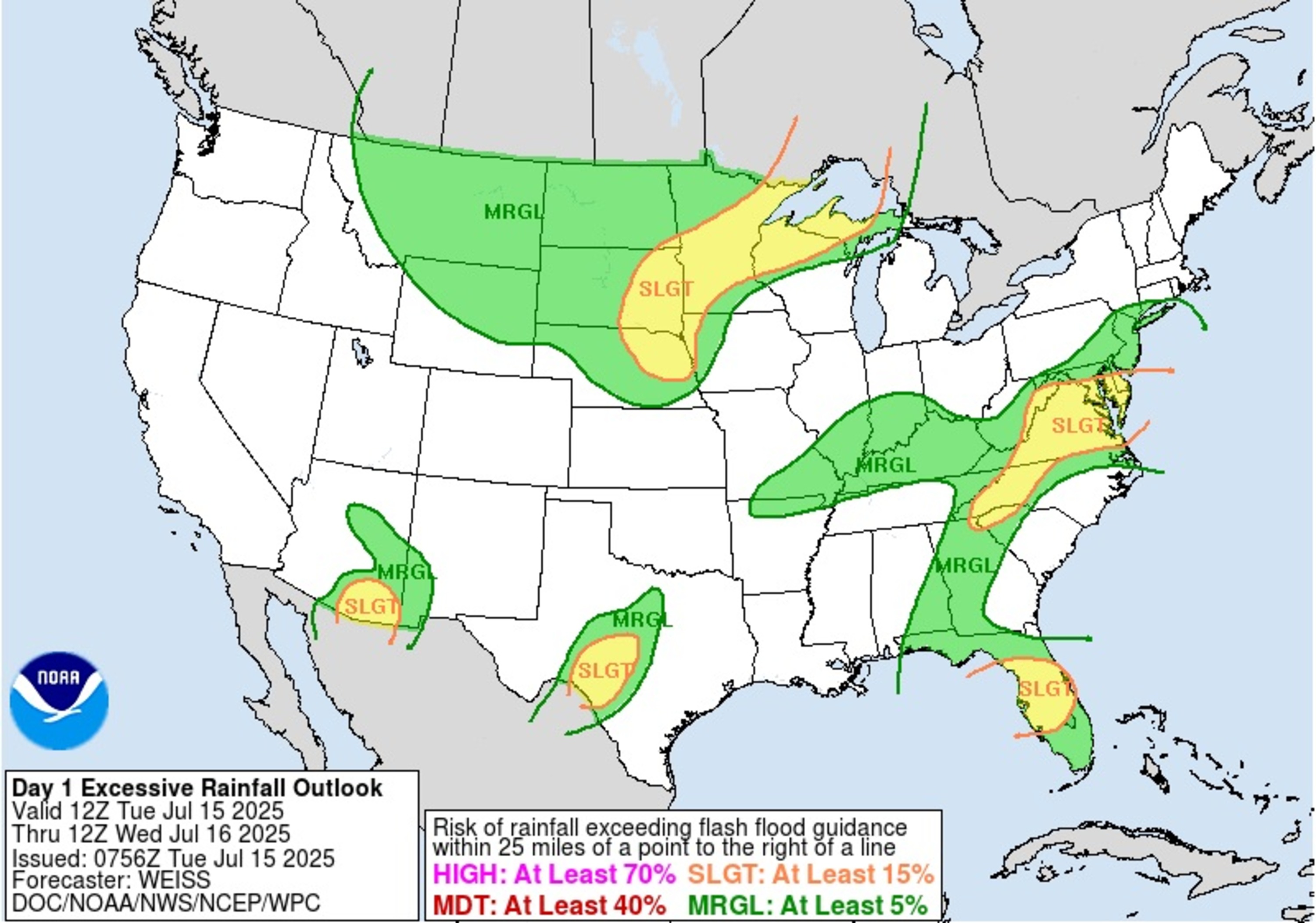
The National Weather Service (NWS) advised some Americans against traveling on Tuesday amid a risk of flash floods in 16 states.
“There are multiple areas where flash flooding is possible today. Any localized flash flooding can have severe impacts,” the NWS said in a post on Facebook. “If a Flash Flood Warning is issued for your area, avoid travel if possible, and never drive into flooded roadways. Turn around, don’t drown!”
Why It Matters
Flooding is the second-deadliest weather hazard in the United States, behind extreme heat.
The warning about flash floods comes as torrential rain has battered multiple parts of the nation over the past few weeks. Two people were killed in Plainfield, New Jersey, on Monday after flash floods swept their car away, marking the second time this month that people have died during storms in the town.
Over the July 4 weekend, Central Texas was inundated with floods that killed more than 100 people. Tropical Storm Chantal moved through parts of the Eastern Seaboard earlier this month, as well. New Mexico, Florida, and numerous other states have recently been affected by dangerous floods amid heavy rainfall.
What To Know
As of Tuesday afternoon, active flash flood warnings were in effect for parts of southern Virginia and northern North Carolina. The warning will remain in place until 4:15 p.m. ET.
Sixteen states are at a slight risk of flash floods on Tuesday, the NWS said. A slight risk means there’s at least a 15 percent chance of rainfall exceeding flash flood guidance.
National Weather Service
The NWS map shows the risk areas as: Michigan’s Upper Peninsula, Northern Wisconsin, Minnesota, far Southeastern North Dakota, Eastern South Dakota, northeastern Nebraska, Southeastern Arizona, Central Texas, Central Florida, far Northeastern Georgia, Northwestern South Carolina, Western North Carolina, Virginia, Eastern West Virginia, Maryland and Delaware.
The heaviest rainfall amounts are expected in Wisconsin, Minnesota and Florida. The latter could see up to 4 inches of rain, according to a rainfall outlook from the NWS Weather Prediction Center.
“Severe thunderstorms are expected across the Central Plains accompanied by damaging wind gusts and large hail,” an NWS forecast said on Tuesday. “In addition, heavy rainfall may lead to instances of flash flooding from the Plains and mid-Atlantic regions. The heavy rainfall threat continues across Florida and across the northern Gulf as we monitor a tropical disturbance tracking westward.”
In addition to the flash flood warning in Virginia and North Carolina, widespread flood watches and flood warnings had been issued across the country.
What People Are Saying
NWS office in Wakefield, Virginia, in a flood warning: “Flooding of rivers, creeks, streams, and other low-lying and flood-prone locations is occurring. Numerous roads remain closed due to flooding.”
NWS office in Austin/San Antonio, Texas, in a flood warning: “Turn around, don’t drown when encountering flooded roads. Most flood deaths occur in vehicles. Be especially cautious at night when it is harder to recognize the dangers of flooding.”
What Happens Next
Most flood warnings are expected to expire by Tuesday evening. AccuWeather Lead Hurricane Expert Alex DaSilva told Newsweek that he is concerned about the potential for flash floods in Louisiana later in the week as heavy rain pummels that region of the U.S.