
‘Omega Block’ Pattern Ahead
An omega block pattern will bring threats of flooding rain to the Plains and Northeast, and some weird temperature maps across the country during the first full week of May.
What Is An Omega Block?
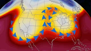
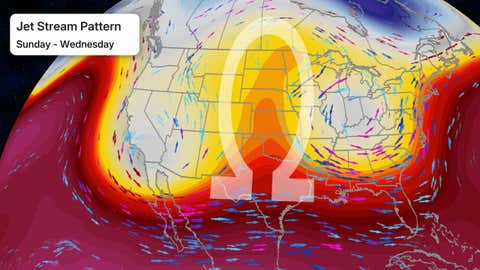
If you trace the path of the jet stream across the U.S. beginning Sunday from the West to the East, you will trace out the Greek letter omega (Ω).
This configuration blocks the typical west-to-east flow of the jet stream, much like a large rock in a small stream forces the flow of water around it. That’s why meteorologists call it a blocking pattern.
How Does It Influence The Weather?
Since it’s a blocking pattern, it means weather systems will slow down for a few days.
To the west and east of the omega block, we usually see slow-moving areas of low pressure, leading to several days of unsettled weather near and just to the east of them.
In roughly the northern half of the omega block, however, the weather is usually dry and sunny with warmer-than-average temperatures.
What Impacts Will We See?
Two Heavy Rain Threats
Several days of locally heavy rain are likely Sunday through at least Wednesday in the Southern Plains, High Plains and lower Mississippi Valley. While parts of the Plains in varying degrees of drought will welcome this rainfall, it will likely worsen both existing river flooding and quickly trigger flash flooding in parts of Oklahoma and northern Texas that just experienced a record wet April.
In the East, multiple days of locally heavy rain are also expected in parts of the Northeast and mid-Atlantic, including the I-95 urban corridor from Washington D.C. to southern New England. While parts of the East are in drought, any persistent bands of heavier rain could also trigger flash flooding, particularly in hilly or urban areas.
(MORE MAPS: Daily U.S. Forecast Precipitation)

Rainfall Outlook
(This should be interpreted as a broad outlook of where the heaviest rain may fall. Higher amounts may occur where bands or clusters of thunderstorms stall for over a period of a few hours.)
Upside-Down Temperatures
For most of the Northwest to the Northern Plains and upper Midwest, you can expect warm weather for several days, from the weekend into at least the first half of the week ahead. This means highs in the 70s or 80s from Montana to Minnesota.
Those areas may be warmer than parts of the Desert Southwest and South. Las Vegas may struggle to reach 70 degrees for a couple of days early in the week. And with the exception of Florida and South Texas, the rest of the South probably won’t warm beyond the 70s or low 80s.
(MORE MAPS: 10-Day U.S. Forecast Highs/Lows)

Forecast High Temperatures
Jonathan Erdman is a senior meteorologist at weather.com and has been covering national and international weather since 1996. Extreme and bizarre weather are his favorite topics. Reach out to him on Bluesky, X (formerly Twitter) and Facebook.