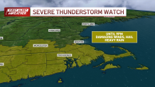
Severe thunderstorm warnings were issued across Massachusetts, including in Boston, and Connecticut and Rhode Island on Friday, where a severe thunderstorm watch was in place through the evening.
See severe weather alerts for your area here, and track the storms with our interactive radar below:
A ground stop was issued at Boston’s Logan Airport due to the storms, according to the FAA. Massport said planes were still able to take off and land at the airport, but flights destined for Boston are being held at their origin airport, leading to delays.
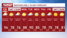
Cooler weather is arriving just in time for the weekend.
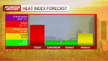
Friday is a First Alert day. We’re tracking heat that you don’t want to play with. In fact, a heat advisory remains in effect for much of our area until 8 p.m. in the evening.
Feels-like temperatures rose above 100 degrees in several neighborhoods this afternoon. So, practice heat safety today. Drink plenty of water, take breaks while outdoors and check on your pets and elderly neighbors during this oppressive heat.
Conditions will dramatically improve this weekend, courtesy of a cold front. Until we can get there, though, many of us will have to dodge showers and storms today.
Extreme heat can pose dangers to people and our pets. Here’s what you need to know amid this round of blazing heat.
The cold front will push scattered showers and storms through parts of Massachusetts, including Greater Boston, Friday afternoon and evening. Some communities will see more rain than others.
NBC10 Boston
NBC10 Boston A severe thunderstorm watch issued by the Naitonal Weather Service for much of southern New England on Friday, July 25, 2025.

NBC10 Boston
NBC10 Boston A weather radar image showing storms moving through Boston and Providence on the afternoon of Friday, July 25, 2025.
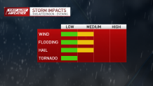
If the storms develop in your area, watch out for gusty winds, heavy rain and hail. When thunder roars, go indoors! Localized flooding is also possible.
NBC10 Boston
NBC10 Boston There’s a low risk for a tornado with storms set to cross Massachusetts Friday, July 25, 2025.
Some of the strongest storms may set up south of the Mass. Pike., but let’s all stay alert today.
Storms should wrap up and clear our area before 9 p.m., giving way to clearing skies and lower humidity.

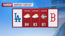
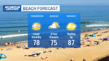
Saturday will feel fantastic due to the lower humidity. High temperatures will be in the upper 70s in Boston and in the 80s away from the coast. We’ll see a mix of sun and clouds.
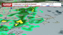
A few scattered showers will push back into the area on Sunday. We’re not expecting rain all day. High temperatures will be in the upper 70s and lower 80s.
Early next week, the humidity will return, along with the heat. We’ll be tracking highs in the upper 80s and lower 90s Monday and Tuesday.